
History
Waterways in Florida were a primary mode of transportation for native populations and the earliest settlers. The Jupiter Inlet was first shown on maps dating back to 1671, according to the U.S. Army Corps of Engineers, and has gone by many names over the years. It was the only outlet for the Loxahatchee River, Lake Worth Creek and Jupiter Sound with part of the flow from the St. Lucie and Indian Rivers diverting to the ocean through the Jupiter Inlet as well. The flow was sufficient to maintain adequate depth through the natural inlet with the exception of severe storms that closed it temporarily for short periods of time.
In the early days, the inlet was several hundred yards South of its present location at times. An 1855 map of the Fort Jupiter Reservation shows the inlet in this position with a more southeastern orientation of the inlet joining the Atlantic Ocean. After the 1892 construction of the St. Lucie Inlet by making an artificial cut through the barrier strip about 10km north of Jupiter, the altered hydrodynamics would in time facilitate the need for management of the Jupiter Inlet to reduce shoaling and maintain a navigable channel.
1890-1891
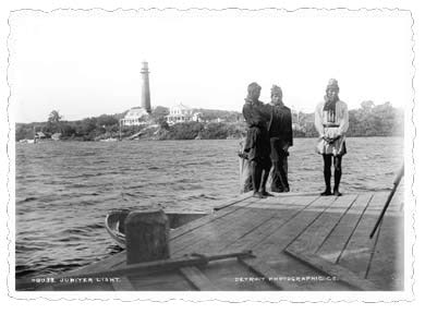
These famed photographs of the Jupiter Inlet and Lighthouse from the Library of Congress were taken by the famed William Henry Jackson (1843-1942) whose works influenced the establishment of Yellowstone and other early national parks.

1905
In October 1905, construction of the U.S. Navy’s Jupiter Wireless Telegraph Station was “nearly complete.” Assigned call letters “RA,” the station soon joined the Navy’s growing roster of wireless installations. The primary function of Navy wireless telegraph stations was communication with warships at sea. The stations provided another valuable service as well: transmission of accurate time signals, which were of great assistance in the days of celestial navigation.

1913
And starting in 1913, U.S. Navy station “RA” also handled commercial radio traffic, both as a public service and to provide Navy operators abundant practice messages. The Navy continued to operate radio communication and direction finding stations at Jupiter Inlet during World War II. More recent installations at the inlet included the U.S. Air Force TEL-4 telemetry station (for communicating with missiles and spacecraft launched from Cape Canaveral) and U.S. Coast Guard LORAN stations.
This postcard image (above right) from the Loxahatchee River Historical Society taken from the Jupiter Lighthouse, looks east to the Jupiter Inlet, with the U.S. Weather Bureau meteorological station in the foreground (Inlet ca 1913).
1913-1922
The Jupiter Inlet moved approximately 1,250 feet North to its present position.
1921
The Jupiter Inlet District was established as an independent special district by special act of the Florida State Legislature to maintain the Jupiter Inlet and a navigable channel from the Loxahatchee River to the Atlantic Ocean.
1922
The Jupiter Inlet remained a natural inlet until 1922. Mr. J.C. Wagen, Chief Engineer of Lake Worth, approved construction drawings that year for the following work at Jupiter Inlet:
- Cutting a channel in the easterly direction across the sand barrier. The channel was to be 100 feet wide at bottom with a 6-foot depth below the mean high-water level, removing 3,000 cubic yards of sand.
- Provision of a barrier across the natural Southeasterly channel in order to divert the flow through the new opening.
- Construction of two jetties, each over 300 feet in length and 300 feet apart.
The permit to dredge a channel and construct two entrance jetties 400 feet apart was issued on April 20, 1922 by Mr. Lansing H. Beach, Major General and Chief Engineer of the U.S. Army. The Jupiter Inlet District built the North and South jetties, both 400-feet in length and dredged a channel 6-feet deep to connect to the Atlantic Ocean.
1929
The North Jetty was extended by 200 feet and the South Jetty was extended by 75 feet.
1930s
By the early 1930s, the jetty on the north side provided stability. The rock ballast is barely visible near the left side of the photo. (LRHS)

1936
100-foot wide, 8-foot deep channel was dredged.
1941
A 6 ft. deep, 60 ft. wide channel was dredged close to the South Jetty.
1940
JID built an angular groin at the seaward end of the South Jetty to increase velocity and induce scouring between the jetties where closure of the inlet had recurred.
1942
Despite those efforts, the inlet closed again and because of the threats posed by German U-boats during WWII off our coast, the inlet remained closed until 1947.
Mid 1940s
By the mid-1940s, a bridge for U.S. 1 spanned the inlet. Part of the bridge remains today as a fishing pier. The more distant road and railroad bridges cross the lower Loxahatchee River.
1947
The inlet was reopened by dredging following the end of WWII.
1956
A 250-foot long concrete capped sheet pile jetty was constructed 85 feet North of the existing North Jetty.
1957-1960
Coastal engineering field study at Jupiter Island was conducted by the University of Florida in order to recommend the best methods of protecting Jupiter Island beaches, ultimately recommending the alignment of the bulkhead along Jupiter Island beach.
Late 1960s
In 1966, JID working with a consulting engineering firm, initiated a 15-year improvement program intended to ultimately provide for:
- Landward extension of the existing bulkheads
- Jetties at the seaward ends of the existing bulkheads
- Continued periodic maintenance dredging of the inlet channel
- A trestle-mounted sand-transfer plan sited North of the North Jetty
The sand trap was dredged 1,000 feet West of the inlet mouth in 1966. In 1967, the angular groin on the seaward end of the South Jetty was removed in an effort to reduce shoaling and both jetties were extended landward to prevent flanking. Continued maintenance dredging of the channel was conducted by the Jupiter Inlet District.
1968
Fisherman take advantage of the recently improved South Jetty.

1992
The Jupiter Inlet District enlists the University of Florida to gather data in developing its Inlet Management Plan rooted in coastal science and hydrodynamics. The plan would call for dredging projects to remove an annual average of 60,000 cubic yards of sand from the inlet’s sand trap for sand bypass and beach placement on beaches South of Jupiter Inlet to counter erosion. The plan would be submitted to and approved by the Florida Department of Environmental Protection (FDEP).
1993
The District enlarges the sand trap by 10,000 square feet to enhance efficiency in trapping sand and decrease sedimentation rates into the Loxahatchee River. The larger trap resulted in a reduction of shoaling, improving navigational safety, and provided larger amounts of sediment for beach renourishment purposes.
1994-1998
After the Jupiter Inlet District Commission adopted the Loxahatchee River Management Plan, it entered into an agreement with Palm Beach County Environmental Resource Management to achieve one of the goals in the plan – to enhance the productivity of the marine and estuarine environment by identifying potential project sites along Sims Creek for tidal creek enhancement.
Sims Creek is a small tributary that flows into the Southwest fork of the Loxahatchee River. The Sims Creek Intertidal Lagoon project created a 2.05-acre mangrove spartina wetland in cooperation with Palm Beach County Environmental Resource Management with the Jupiter Inlet District providing a 50% funding match. In addition, 0.3 acres of exotic vegetation was cleared, primarily Melaleuca, to eliminate a seed source that could have otherwise spread to other portions of the area. The enhancement and restoration of the wetland portion of the site are important management tools that have provided additional habitat for fisheries and wildlife species. The project was completed in 1998.
1996-1997
The Jupiter Inlet District completed its Oxbow Restoration project at four sites within Jonathan Dickinson State Park. Boat traffic had resulted in the destruction of mangrove shorelines and the breaching of narrow divisions between adjacent channels. These breaches effectively straightened the channel by shortcutting historical meanders, thereby allowing more direct tidal influence upon upstream reaches. Closure of the gaps (1) improved water quality in stagnant areas; (2) reduced organic deposition in isolated oxbows; and (3) increased retention time of freshwater runoff in the Northwest Fork and decrease saltwater intrusion. Two of the four gaps were closed during 1996, with the remaining two gaps closed in February, 1997.
The gaps were plugged with a barrier of core stone placed upon a geotextile layer. This core was faced with a layer of larger armoring rock. The top of the plug was then planted with mangroves, thus providing a hydraulic barrier which was biologically and aesthetically compatible with the surrounding state park. Project performance has been evaluated through use of salinity probes placed in the river upstream and downstream from the gap closures. Additionally, water quality testing show the effects of improved flushing resulting from gap closures.
1997
In the foreground of this 1997 aerial photograph, a dredge pumps material from the “sand trap” in Jupiter Inlet and deposits it on the beach South of the inlet. To the West, beyond the bridges, are the Loxahatchee River Central Embayment and the river’s North and Northwest Forks.
Photo credit: National Oceanographic & Atmospheric Administration Photo Library (Mrs. Marge Beaver, photographer)

1997-1998
From 1997 to 1998, the Jupiter Inlet District engaged in a project to raise the elevation of both the North and South jetties, and extend the South jetty to improve navigational safety, improve sediment bypass and reduce sedimentation in the Loxahatchee estuary. The seaward end of both jetties were raised by 2-feet and the South jetty was extended by 200 feet with a southeastern curve at its tip. Construction included the installation of two parallel sheet-pile walls with sand backfill and a reinforced concrete deck to enhance pedestrian access. Additional modifications included granite riprap extensions at the western ends of each jetty to prevent flanking and to afford protection to newly planted vegetation by the South jetty and a small swimming beach by the North Jetty.
The extension of the South jetty reduced beach erosion immediately downdrift of the inlet by virtue of enlarging the region sheltered against wave action, and by reducing the natural transport of sand-laden water around the jetty occurring with each flood tide. Similarly, raising the jetties reduced the transport of sand over each, which occurred during significant storms. Any reduction of sand influx into the inlet also results in a proportional reduction into the Loxahatchee Estuary.
2001-2002
Sims Creek Siltation Removal Project was completed by the Jupiter Inlet District to reduce sediment loads into the Loxahatchee River. Sims Creek experienced severe shoaling between 1980 and 2000, reducing navigable depths along the upper reach of the creek by 2-3 feet and substantially constricting the effective water conveyance widths. The primary shoaling occurred in two storm events, March 1982 and October 1995. Both associated with major structural blowouts that brought large volumes of sand into the creek from the Northern Palm Beach Heights Water Control District canal system. In 2001, the Jupiter Inlet District restored the upper reaches of Sims Creek to depths and cross sections comparable with historical depths and compatible with its use. Silt bottom material was removed from the middle and lower reaches and placed in the District’s Dredged Material Management Area (DMMA).
2006
In 2006, the Jupiter Inlet District undertook remedial repairs to the jetties, including the addition of armor stone and, for the North jetty, demolition of the old sheet pile core and repair to cracking concrete. The armor stone was added where stone loss was observed to have occurred with the passage of Hurricanes Frances and Jeanne in 2004 that caused major devastation in our area.
2007
The Jones Creek Phase II project was completed by the Jupiter Inlet District in 2007 as part of the Loxahatchee River Management plan. The purpose was to restore Jones Creek to historic depths which would provide for a more stable benthos and reduction of sediment loads into the Loxahatchee River. Exotic vegetation removal was also a focus to increase shoreline access.
Jones Creek is a primary urban tributary to the Loxahatchee River. Both the natural portion and manmade extensions of the creek receive stormwater runoff from commercial, industrial and residential areas within the Town of Jupiter. Over the many years of development within the 1600 ± acre Jones Creek Basin, the creek has also received runoff from numerous construction sites, as well as runoff and groundwater flow from residential areas previously on septic tanks. This has resulted in considerable deposition of organic and inorganic material, particularly in the upper (manmade) reaches of the system. The restoration effort included the removal of 4,000 cubic yards of sediment, a source of pollution to the Loxahatchee River. The Jupiter Inlet District received all the necessary permits by early 2007 and the project was completed in December of that year. The total cost was $247,000, some $500,000 under the original projected budget.
2014
After decades of work with state and federal partners, the Jupiter Inlet District created the South Shoreline Access Channel in the Loxahatchee River's Central Embayment, located within the larger Loxahatchee River-Lake Worth Creek Aquatic Preserve.
The 1,500-foot long channel was dredged to depth of -5 ft. NGVD with a width of 50-feet, connecting to the Main Channel in the Central Embayment on the East and the Southwest fork of the Loxahatchee River to the West. With extensive seagrass in the area - all located within the larger aquatic preserve - this new channel gave boaters accessing the waterway from the southern shoreline a navigable channel to avoid cutting through the seagrass beds to connect to the Main Channel. Channel markers were installed by and are maintained by the Jupiter Inlet District.
2019
The Jupiter Inlet District worked collaboratively with the Florida Inland Navigation District (FIND) on a project to restore and protect the one remaining mangrove island in the Loxahatchee River's Central Embayment. For more information, visit our Projects & District News page.
2020
The Moonshine Creek Oxbow Restoration project would mark the farthest project site upriver undertaken by the Jupiter Inlet District. Located in the Loxahatchee River Northwest fork's Wild and Scenic River, the focus was restoration and preservation of historical and natural resources while returning the river to its meandering flow. Work was completed in February of 2020.
2021
The Jupiter Inlet Districts celebrates 100 years of continuous operation.
In this year, District officials approve plans for and oversee multiple projects that including dredging the inlet sand trap and placing sand on downdrift beaches, constructing a living shoreline and observation pier at the Jupiter Inlet Lighthouse Outstanding Natural Area (JILONA), and two restoration projects in the Loxahatchee River’s Northwest fork – Mile 6 Gap Closure and Oxbow Restoration and Moonshine Creek Oxbow Restoration. Visit our Project & District News page for details.